As an Amazon Associate, I earn from qualifying purchases. Some links in this article are affiliate links, if you buy through them I may earn a small commission at no extra cost to you.
Most gardeners use USDA planting zones completely wrong. They’re a perennial hardiness tool, not a planting calendar, and confusing the two is how you end up with dead tomatoes in May.
While the United States Department of Agriculture (USDA) Plant Hardiness Zone Map is the most widely referenced tool in North American gardening, it’s also the most commonly misunderstood. Many growers, particularly those planting annual vegetables, make costly mistakes by relying on these zones for the wrong information. When I first transitioned from indoor hydroponics (where we control every single variable in a reservoir) to traditional soil-based growing, I fell into this exact trap myself. If you’re deciding between the two methods, check out our comparison on hydroponics vs. traditional gardening.
This guide breaks down what planting zones actually measure, why they’re frequently misunderstood, how the recent USDA map update affects you, and how to use complementary tools to build a thriving garden.
What Are USDA Planting Zones?
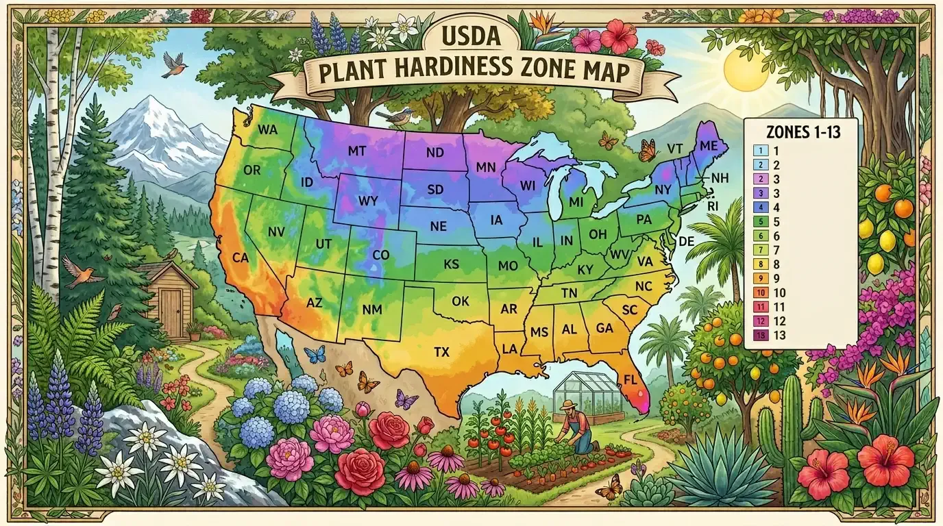
The USDA Plant Hardiness Zone Map divides North America into 13 distinct zones based on a single metric: the average annual extreme minimum winter temperature.
Each zone represents a 10°F difference in the lowest average winter temperature, and each is split into “a” and “b” subzones (representing 5°F increments) for greater precision:
- Zone 1 is the coldest, dropping to -50°F (-45.6°C) or lower.
- Zone 13 is the warmest, where winter lows rarely dip below 60°F (15.6°C).
If a plant tag says “Hardy to Zone 6,” it means that the plant’s root system can typically survive the average minimum winter temperatures of Zone 6 (which range from -10°F to 0°F). For a list of plants that can handle freezing temperatures, see the ultimate guide to frost-tolerant plants.
The Biggest Misconception: Perennials vs. Annuals
Among gardening communities on forums like Reddit, the most frequent point of confusion is the difference between a hardiness zone and a planting window.
📌 The Rule of Thumb
- USDA Zones are strictly for perennials (trees, shrubs, and perennial flowers/vines that must survive the winter).
- USDA Zones are largely irrelevant for summer annuals (tomatoes, peppers, squash, cucumbers, and basil).
Many beginners assume that being in a warmer zone (like Zone 8 or 9) means they can automatically start planting their tomatoes earlier in the spring. However, USDA zones do not measure when your last spring frost occurs.
For example, a coastal region in Scotland and a high-altitude desert in Colorado can share similar mild winter minimums (putting them both in a warm USDA zone like 8 or 9). Yet, the Colorado desert has intense summer heat and a short, volatile frost-free window, while Scotland has cool, damp summers and a completely different seasonal timeline.
What to Use Instead for Annuals:
If you’re planting annual vegetables or summer flowers, ignore your USDA zone. Instead, look up your average last frost date and soil temperatures to plan your spring window (see our detailed guide on planning a small vegetable garden from scratch for step-by-step layout tips):
- Your Average Last Frost Date: This is the estimated date in spring when the chance of a freezing frost drops below 50%.
- Soil Temperatures: Many warm-season crops (like tomatoes and melons) will stunt or rot if planted in soil below 60°F (15.6°C), regardless of whether the air temperature is warm.
Why the Recent USDA Map Update Can Be Deceptive
In late 2023, the USDA released an updated Plant Hardiness Zone Map based on 30 years of weather data (covering 1991 through 2020). Because of a general warming trend, roughly half of the United States shifted up into a warmer half-zone or full zone (for example, moving from Zone 7a to 7b).
While this update accurately reflects long-term climate “normals,” seasoned gardeners advise caution:
- Averages Paper Over Extremes: USDA zones are calculated using averages. They don’t account for extreme, volatile weather events. I learned this lesson the hard way back in 2021 when a sudden late February polar vortex hit my Zone 7 garden, dropping temperatures to a bitter -5°F for three consecutive nights. My young “Elberta” peach tree, which I’d optimistically planted thinking my local climate was warming up, died to the roots. The zone map said I was safe, but the weather didn’t care about the averages. A region classified as Zone 9a can still experience a historic polar vortex that drops temperatures down to Zone 7 levels for a few days, killing any tender citrus or tropical plants you chose based on the new map.
- Climate Volatility is Rising: Even as average temperatures warm, climate change has introduced more unpredictable weather swings. Late-season freezes or sudden, unprecedented cold snaps are still highly possible.
The takeaway: If you plan to grow expensive, slow-growing perennial specimens (like fruit trees or privacy hedges), it’s often safest to select plants rated one full zone colder than your official zone to build in a safety buffer. In my own yard, I now buy fruit trees rated for Zone 6 (like my hardy “Redhaven” peach). This extra buffer gives me peace of mind when the winter winds start howling.
Alternative Maps for Smarter Gardening
To get a complete picture of your local climate, experienced gardeners often cross-reference the USDA map with alternative classification systems.
1. Sunset Climate Zones (Mainly for the Western U.S.)
For gardeners in complex climates (such as the West Coast, where mountains, valleys, and ocean breezes create wildly differing conditions over short distances), the USDA map is often insufficient.
The Sunset Climate Zone system divides the region into 45 distinct zones. Unlike the USDA map, Sunset factors in multiple critical environmental variables:
- Total rainfall and humidity: Factoring in whether a plant will face damp, rot-prone conditions or bone-dry air.
- Elevation: Crucial for mountain and valley gardeners who experience drastically different temperature swings than coastal neighbors.
- Ocean influence (marine layers): Factoring in cool ocean breezes, fog, and humidity.
- Length of the growing season: Measuring the actual number of frost-free days available for growth.
To see how important this is, compare USDA Zone 9 in Seattle, Washington, with USDA Zone 9 in Phoenix, Arizona. On the USDA map, they’re grouped similarly because they share similar average winter minimums. However, if you try to grow Phoenix plants in Seattle, they’ll rot from the cold moisture, and Seattle plants will scorch in Phoenix. Sunset zones solve this by placing Seattle in Sunset Zone 5 (cool, wet marine) and Phoenix in Sunset Zone 13 (desert transition zone). A plant that struggles in the damp coastal fog of San Francisco (Sunset Zone 17) might thrive in the hot, dry interior valley of Sacramento (Sunset Zone 14), even though both areas share a very mild winter.
2. AHS Heat Zones
While cold hardiness determines if a plant will survive the winter, heat tolerance determines if it will survive the summer. When temperatures climb too high, plants experience severe physiological heat stress, cell membranes can break down, proteins denature, and excessive transpiration leads to immediate wilting and stunting.
The American Horticultural Society (AHS) Heat Zone Map tracks the average number of “heat days” per year (days where temperatures climb above 86°F/30°C). This is particularly useful for cool-weather crops like spinach, brassicas, and cilantro, which will bolt (go to seed) immediately if you plant them during high AHS heat periods. It’s also critical for perennials like certain rhododendrons, hostas, or conifers; they might survive your winter cold perfectly, but they will slowly decline and die if they are subjected to months of blistering summer heat beyond their AHS rating.
3. EPA Ecoregions
If your goal is to plant a low-maintenance, native habitat, look up your local EPA Ecoregion (Level III or IV). Instead of looking just at temperatures, EPA ecoregions map entire biological communities based on local geology, soil structures, native hydrology, and wild vegetation patterns.
Choosing plants native to your specific ecoregion ensures they’re naturally adapted to your local soil microbes and rainfall patterns. For instance, rather than buying a generic “native wildflower mix” that includes species native to a completely different part of the country, checking your ecoregion helps you choose species that will establish deep root systems and require zero supplemental watering or artificial fertilizer because they co-evolved with that exact soil chemistry.
Tips for Working with Your Local Environment
Instead of relying solely on a national map, look closely at your own property to identify and manipulate microclimates:
- Thermal Mass: Planting tender perennials against a south-facing brick, stone, or concrete wall can radiate heat back to the plants overnight, effectively raising their local climate by a half-zone. For example, I have a large rosemary shrub planted directly against the red brick chimney on the south side of my house. While my neighbors struggle to keep their rosemary alive through wet, freezing winters, mine thrives because the bricks absorb the winter sun and release heat all night.
- Wind Protection: Cold winter winds can desiccate evergreen foliage. Planting sensitive shrubs behind windbreaks (such as fences or hardy conifers) increases their chances of winter survival.
- Low Spots and Frost Pockets: Cold air is dense and sinks. If your garden is at the bottom of a slope or valley, it may experience colder winter temperatures and later spring frosts than a neighboring property on a hillside.

- Protect Tender Crops: When a late freeze threatens, using physical coverings is one of the most effective ways to preserve plants and extend your growing season (see our detailed guide on how to use row covers and frost cloths effectively).

Plant Covers for Frost Protection
I've used these lightweight floating row covers to protect my early spring lettuce starts and tender potato shoots from sudden late frosts in my garden. Unlike heavy blankets, they're light enough that they won't crush delicate foliage, and unlike plastic sheets, they let air and water circulate freely so plants don't overheat or rot during the day. They easily trap enough ground heat to keep frost from burning the tips of your crops.
- Consult Local Experts: For planting calendars tailored to your specific county, consult your state university’s agricultural extension office. Their guides are backed by years of localized research and are far more precise than any generalized internet search.
Winter Survival vs. Spring Planting
At the end of the day, success in the garden comes down to using the right tool for the right job. Keep your USDA zone in mind for winter survival of your trees and shrubs, but rely on frost dates and soil temperatures to decide when to plant your vegetables. By understanding your specific microclimates and regional maps, you’ll save yourself time, money, and the heartbreak of lost crops.
Editor’s Note: Parts of this guide were structured and optimized with the assistance of AI, then thoroughly reviewed, edited, and expanded with first-hand growing experience by our author Raymond to ensure practical, real-world accuracy.
Frequently Asked Questions
What do USDA planting zones actually measure?
USDA zones measure only one specific metric: the average annual extreme minimum winter temperature. They do not measure frost dates, soil temperatures, maximum summer heat, or rainfall, making them critical for perennial survival but mostly irrelevant for summer annuals.
Can I use USDA zones to decide when to plant my vegetables?
No. USDA hardiness zones do not indicate frost-free windows or when the soil warms up. For summer annuals like tomatoes, peppers, and cucumbers, you should ignore your USDA zone and instead rely on local average last frost dates and soil temperature guidelines.
What is the difference between USDA zones and Sunset climate zones?
While the USDA map is based solely on winter cold, Sunset climate zones factor in multiple critical variables: total rainfall, humidity, elevation, wind, growing season length, and marine influence. This makes Sunset zones far more precise, especially in complex Western climates.
Why should I select plants rated one zone colder than my actual zone?
Because USDA zones are calculated using historical averages, they do not account for extreme weather anomalies like a polar vortex. Choosing plants rated one zone colder provides a safety buffer, protecting your long-term perennial investments from unusual winter freezes.
Our Amazon Storefront
Browse all our recommended tools & supplies
Everything we personally use and trust — hand-picked for gardeners like you.

I've been running DWC and Kratky systems for several years and write about what actually works, not textbook theory. Follow along for honest product reviews, practical guides, and real grow results.